Table of Contents
In the world of modern positioning technology, RTK (Real-Time Kinematic) and NTRIP (Networked Transport of RTCM Data) are two terms that often come up, especially in applications like autonomous vehicles, drones, surveying, and precision agriculture. While they’re related, they serve distinct roles. In this blog, we’ll break down what each technology does, how they work together, and why they’re transforming industries worldwide.
What is RTK?
RTK stands for Real-Time Kinematic, a satellite-based positioning technique that provides centimeter-level accuracy in real time.
It achieves this by using a network of reference stations (ground-based GPS receivers) to calculate precise corrections for errors in GPS signals. Here’s how it works:
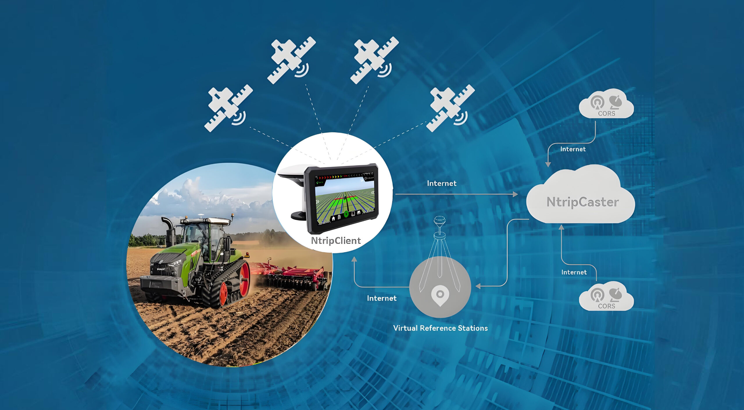
Reference Stations: These stations continuously monitor GPS satellite signals and compute error corrections (like atmospheric delays, signal multipath effects, and orbital inaccuracies).
Data Transmission: The corrections are sent to a user’s device (a “rover”) via a data link (e.g., radio, cellular networks, or NTRIP).
RTK Receiver: The rover combines the corrected data with its own GPS measurements to determine its exact position with centimeter-level precision.
Key Benefits of RTK:
High Accuracy: Ideal for tasks requiring pinpoint precision (e.g., construction, agriculture, robotics).
Real-Time Updates: Enables dynamic adjustments for moving vehicles or machinery.
What is NTRIP?
NTRIP is a protocol standard designed to transmit RTCM (Radio Technical Commission for Maritime Services) data over the internet. It acts as a “data pipeline” to deliver real-time corrections from reference stations to RTK-enabled devices. Without NTRIP, RTK would rely on older, less efficient methods like radio or direct file transfers.
How NTRIP Works:
RTCM Data Generation: Reference stations generate RTCM messages containing error corrections.
Internet Transmission: NTRIP streams these messages over the internet to any compatible device (smartphone, drone, etc.).
Seamless Integration: The device uses the RTCM data to perform RTK calculations in real time.
Why NTRIP Matters:
Global Accessibility: Users can access RTK services from anywhere, without needing a local reference station.
Cost-Effective: Eliminates the need for expensive hardware or long-range radio infrastructure.
Scalability: Supports thousands of users simultaneously via cloud-based networks.
RTK vs. NTRIP: A Synergistic Relationship
While RTK is the “engine” for high-precision positioning, NTRIP is the “fuel line” that delivers the data needed to power it. Here’s how they work together:
Role RTK NTRIP
Function Calculates precise positions in real time. Transmits RTCM data over the internet.
Data Type Uses RTCM corrections for calculations. Transports RTCM data globally.
Infrastructure Requires reference stations and a data link. Relies on internet connectivity.
Example Workflow:
A network of reference stations (e.g., Trimble, Leica) generates RTCM data.
NTRIP streams this data to a user’s RTK-enabled device (e.g., a farmer’s tractor).
The device applies the corrections to GPS signals, achieving centimeter-level accuracy for planting or navigation.
Applications of RTK + NTRIP
The combination of RTK and NTRIP has unlocked breakthroughs in diverse fields:
Autonomous Vehicles: Enables self-driving cars to navigate safely in tight spaces.
Precision Agriculture: Farmers use RTK-guided tractors to plant crops with millimeter accuracy.
Surveying & Mapping: Drones and handheld devices create ultra-detailed maps.
Construction: Cranes and excavators automatically adjust their positions to avoid collisions.
Fencing & Land Management: Automates boundary marking with high precision.
The Future of Positioning
As 5G and satellite constellations (like Starlink) roll out, NTRIP will become even faster and more reliable. Combined with RTK, we can expect:
Wider Coverage: Rural areas gain access to high-precision RTK.
Lower Costs: Smaller businesses and consumers can afford advanced positioning tools.
New Innovations: From smart cities to drone delivery, RTK+NTRIP will enable next-generation applications.
Conclusion
RTK and NTRIP are not competitors—they’re complementary technologies that together deliver unmatched positioning accuracy. Whether you’re mapping a forest, steering a self-driving car, or planting crops, they’re the invisible backbone of precision.
Ready to explore how RTK + NTRIP can transform your business? Contact us to learn about our RTK solutions and NTRIP-compatible devices!
Stay ahead of the curve—precision is the new currency of innovation.